Search This Blog

Sunday 17 January 2016

Creating WiFi map and monitoring access points based on geographic information system (OpenWebGIS)


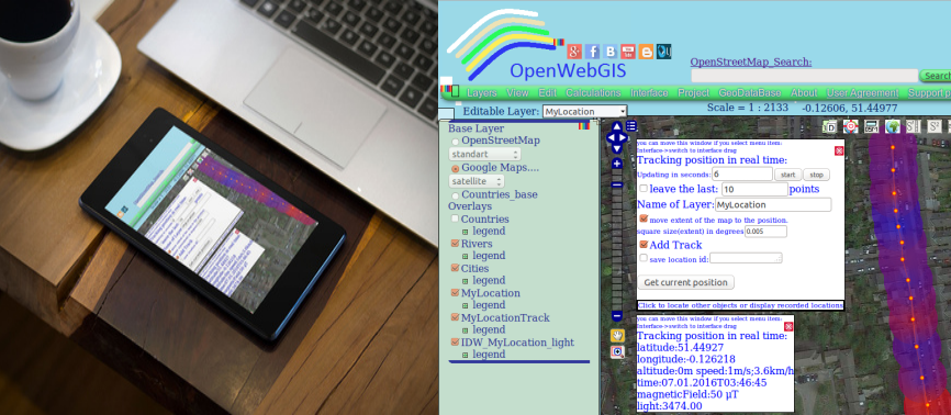
Maybe you want to create for yourself the WiFi map of the place you have visited, or maybe you want to collect and monitor parameters of WiFi-points? Do you want to create a map legend, mathematically analyze the information about a detected access point, export this data to popular Geographic information system (GIS) formats (gml, kml, geoJSON, osm, gpx or csv)?

«Wi-Fi (or WiFi) is a local area wireless computer networking technology that allows electronic devices to connect to the network, mainly using the 2.4 gigahertz (12 cm) UHF and 5 gigahertz (6 cm) SHF ISM radio bands»
In order to use the WiFi access point (or hotspot) it is necessary to know the geographic location of this point and its parameters (properties), for example, such as network name, authentication, key management, and encryption schemes, frequency, signal level, etc.

Friday 8 January 2016

Use maps and sensors in your phone as one tool with the help of OpenWebGIS


Now, many phones, smartphones, tablets and so on (your mobile devices) have accelerometers, gyroscopes, magnetic field sensors, light (illumination) sensors, pressure sensors, etc. Data from these sensors is used in various applications for Android (hereinafter, it will be written about the use of sensors in the operating system Android). For different purposes, it may be useful not only to get (detect the parameters changes) the sensor output at any time, but to collect them during a large period of time with the reference to the space (map). For example it will be interesting to measure the illumination of the night streets in your city block, then interpolate these data and mathematically determine places where it is necessary to add a street lamp, or identify places where there is more magnetic field strength. It may be interesting to follow the direction change of your phone in space and in time according to cardinal points or follow your phone rotation angles according to the axes (x, y, z), for example so you can determine the moments when the phone is next to your ear during a call.

You can collect sensor data and refer them to the geographical coordinates in OpenWebGIS. To do this, first turn on geolocation of your device . Then you need to run on your device OpenWebGIS version for Android, after that select in the first window - local version (see Figure 1).