All buildings
views (like 3D) given in this article were created with the help of OpenWebGIS and OSM Buildings.
Read more about the integration of OpenWebGIS and OSM Buildings here: http://blog.osmbuildings.org/2015/06/integration-of-openwebgis-with-osm.html. At the end of the article there
will be a description of how to create such maps in OpenWebGIS by yourselves.
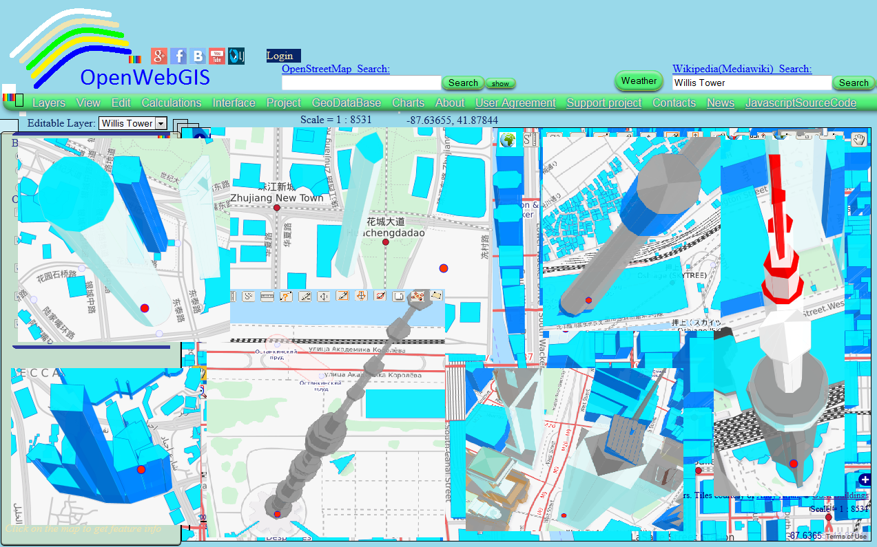
10. The Willis Tower. Pinnacle height: 527 m; opening year 1974. It was built as and still commonly referred to as Sears Tower, is a 108-story,
1,451-foot (442 m) skyscraper in Chicago, Illinois, United States. See Figure
1 and open Map 1.
 |
| Figure 1 |
9. CTF Finance Centre. Pinnacle
height: 530 m; opening year 2015. Formerly
The CTF Guangzhou, Chow Tai Fook Centre (simplified Chinese: 周大福商业中心; traditional Chinese: 周大福商業中心) is a supertall skyscraper under
construction in Guangzhou, China. It will be the second of the two Guangzhou
Twin Towers skyscrapers overlooking the Pearl River in Guangzhou. Its final
height will be 530 metres (1,740 feet) with 111 floors. See Figure 2 and open
Map 2.
 |
| Figure 2 |
8.
Ostankino Tower (Russian: Останкинская телебашня, Ostankinskaya telebashnya).
Pinnacle height: 540 m; opening year 1967. It is a television and radio tower
in Moscow, Russia, owned by Moscow branch of unitary enterprise Russian TV and
Radio Broadcasting Network. Standing 540 meters (1,772 ft) tall, Ostankino was
designed by Nikolai Nikitin. It is currently the tallest freestanding structure
in Europe and eighth tallest in the world. The tower was the first
free-standing structure to exceed 500 m (1,600 ft) in height. See Figure 3 and
open Map 3.
 |
| Figure 3 |
7. One World Trade Center. Pinnacle
height: 546.2 m; opening year 2013 (also known as 1 World Trade Center, One WTC
and 1 WTC; the current building was dubbed the "Freedom Tower" during
initial base work). It refers to the main building of the new World Trade
Center complex in Lower Manhattan, New York City. It is the tallest skyscraper
in the Western Hemisphere and the fourth-tallest in the world. See Figure 4 and
open Map 4.
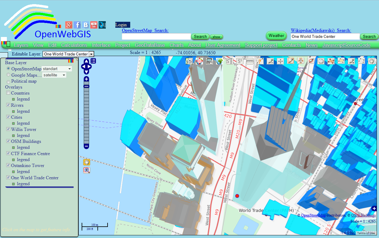 |
| Figure 4 |
6. The CN Tower (French: Tour CN). Pinnacle
height: 553 m; opening year 1976. It is concrete communications and observation
tower in Downtown Toronto, Ontario, Canada. Built on the former Railway Lands,
it was completed in 1976, becoming the world's tallest free-standing structure
and world's tallest tower at the time. It held both records for 34 years until
the completion of Burj Khalifa and Canton Tower in 2010. It is now the 3rd
tallest tower in the world and remains the tallest free-standing structure in
the Western Hemisphere, a signature icon of Toronto's skyline, and a symbol of
Canada, attracting more than two million international visitors annually.
See Figure
5 and open Map 5.
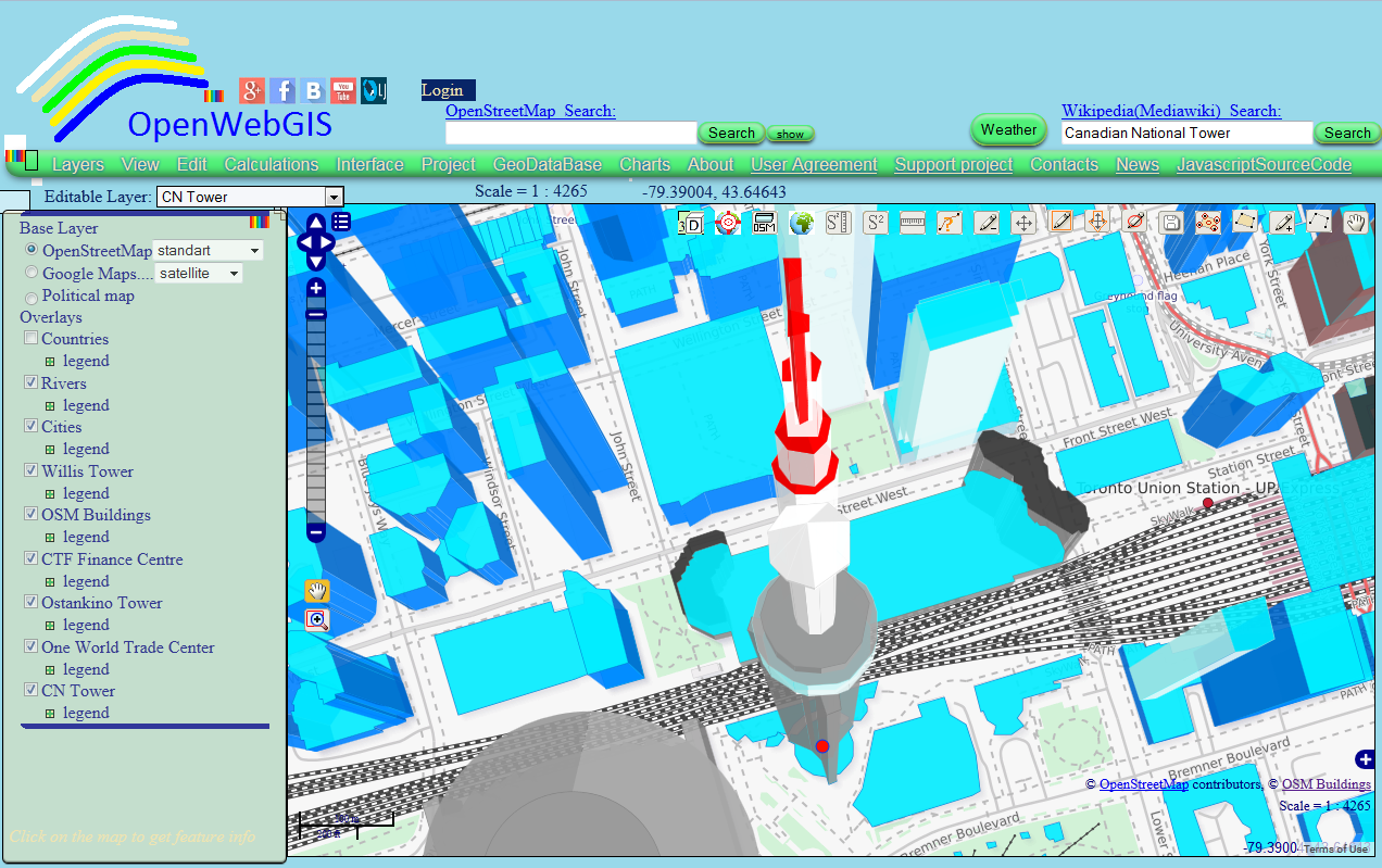 |
| Figure 5 |
5. Canton Tower (Chinese: 广州塔). Pinnacle height: 600 m; opening year 2010. It is a tall multi-purpose
observation tower in the Haizhu District of Guangzhou (historically known as
Canton or Kwangchow), Guangdong, China. The tower was topped out in 2009 and it
became operational on 29 September 2010 for the 2010 Asian Games. The tower
briefly held the title of tallest tower in the world, replacing the CN Tower,
before being surpassed by the Tokyo Skytree. It was the tallest structure in
China prior to the topping out of Shanghai Tower on 3 August 2013. It is now the
third tallest tower and the fifth-tallest freestanding structure in the world. See Figure
6 and open Map 6.
 |
| Figure 6 |
4. The Abraj Al-Bait Towers. Pinnacle height: 601 m; opening year
2011. It is also known as the Makkah Royal Clock Tower Hotel and it is a
government-owned megatall building complex in Mecca, Saudi Arabia. These towers
are a part of the King Abdulaziz Endowment Project that strives to modernize
the city in catering to its pilgrims. The central hotel building has the
world's largest clock face and is the third tallest building and fourth tallest
freestanding structure in the world. The building complex is meters away from
the world's largest mosque and Islam's most sacred site, the Masjid al-Haram. See Figure
7 and open Map 7.
 |
| Figure 7 |
3. The Shanghai Tower (Chinese: 上海中心大厦). Pinnacle height: 632 m; opening year 2015. It is a megatall skyscraper under
construction in Lujiazui, Pudong, Shanghai. It is designed by Gensler and owned
by a consortium of Chinese state-owned companies. It is the tallest of a group
of three adjacent supertall buildings in Pudong, the other two being the Jin
Mao Tower and the Shanghai World Financial Center. The building stands
approximately 632 metres (2,073 ft) high and has 128 stories, with a total
floor area of 380,000 m2 (4,090,000 sq ft). Its tiered construction, designed
for high energy efficiency and sustainability, provides multiple separate zones
for office, retail and leisure use. The Shanghai Tower is projected to open to
the public in mid-2015.
See Figure
8 and open Map 8.
 |
| Figure 8 |
2. Tokyo Skytree (東京スカイツリー Tōkyō Sukaitsurī). Pinnacle
height: 634 m; opening year 2012. It is a broadcasting, restaurant, and
observation tower in Sumida, Tokyo, Japan. It became the tallest structure in
Japan in 2010 and reached its full height of 634.0 meters (2,080 ft) in March
2011, making it the tallest tower in the world, displacing the Canton Tower and
the second tallest structure in the world after Burj Khalifa (829.8 m/2,722
ft). See Figure
9 and open Map 9.
 |
| Figure 9 |
1. BurjKhalifa (Arabic: برج خليفة, "Khalifa Tower", pronounced English
/ˈbɜrdʒ kəˈliːfə/). Pinnacle
height: 829.8 m; opening year 2010. It is known as Burj Dubai before its
inauguration, is a skyscraper in Dubai, United Arab Emirates. It is the tallest
man-made structure in the world, standing at 829.8 m (2,722 ft). Construction
began on 6 January 2004, with the exterior of the structure completed on 1
October 2009. The building officially opened on 4 January 2010, and is a part
of the new 2 sq.km (490-acre) development called Downtown Dubai at the 'First
Interchange' along Sheikh Zayed Road, near Dubai's main business district. The
tower's architecture and engineering were performed by Skidmore, Owings and
Merrill of Chicago, with Adrian Smith as chief architect, and Bill Baker as chief
structural engineer. The primary contractor was Samsung C&T of South Korea.
The tower's construction was done by the construction division of Al Ghurair
Investment group.
See Figure
10 and open Map 10.
 |
| Figure 10 |
How to create such maps as shown above using
OpenWebGIS, OSM buildings and Wikipedia:
1. You must add the "OSM Buildings" Layer
on the map by click on the button:
 in the upper right corner of the map. This button has the title: "OSM
Buildings. Click for visualizing OpenStreetMaps building geometry ...".
After that in the list of layers on the left of the map there will be the new
"OSM Buildings" layer. See the Figure 11 to get more information.
in the upper right corner of the map. This button has the title: "OSM
Buildings. Click for visualizing OpenStreetMaps building geometry ...".
After that in the list of layers on the left of the map there will be the new
"OSM Buildings" layer. See the Figure 11 to get more information.
 |
| Figure 11 |
2. Insert in the "Wikipedia (Mediawiki)
_Search:" field name of the object you are interested in. For example
"Acropolis of Athens" and press button "Search", then a
list of found objects will appear. See the Figure 12.
 |
| Figure 12 |
3. Move the cursor to the list of found items and
there will be a brief description of the object. See the Figure 12.
4. If the object contains coordinates in an article
of Wikipedia in the format shown in Figure 13, then you can click on the name
of the object, then in the list of map layers a layer will be added containing
a point with the specified coordinates (see Figure
14).
 |
| Figure 13 |
 |
| Figure 14 |
5. Select the name of your layer (for example,
"Acropolis of Athens") in "Editable Layer" drop-down list, like it is
shown in Figure 15.
 |
| Figure 15 |
6. Zoom the map to a layer extent with the
coordinates of the object you have selected. To do this, click on the menu item
"Layer"-> "Zoom to Layer" and you will see the result shown in Figure 16.
 |
| Figure 16 |
7. You can change the coloring of objects, for this
click on menu item "Edit" -> "Edit OSM Buildings Layer" and set the desired parameters (as shown in Figure 17).
 |
| Figure 17 |
8. You can create a link to your map to show it to
your colleagues and friends, for this use the button

 |
| Figure 18 |
The result on the
map can be viewed at this link: http://opengis.dlinkddns.com/gis/opengis_eng.html?openwebgis=ejPxEFDOeFcfxQ7JKVkFTm1t
The process of creating the map you can see on this video:
The process of creating the map you can see on this video:
No comments:
Post a Comment